Early polar vortex arrival expected across Canada!
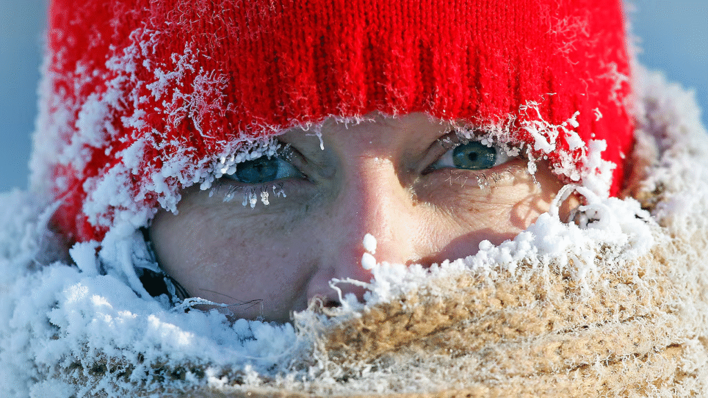
Canada may soon face an early polar vortex arrival, as new atmospheric models signal a sharp drop in temperatures across Western and Central regions. Although the polar vortex is a constant feature of the upper atmosphere, it can occasionally weaken and push Arctic air southward. This appears to be the case now, according to leading climatologists monitoring rapid changes in the stratosphere. As a result, colder-than-normal conditions could develop as early as next week. Moreover, forecasters warn that the chill may expand eastward if current patterns continue. Because of this potential shift, Canadians are being urged to prepare for a significant and early winter outbreak.
A returning weather pattern that captured attention in 2014
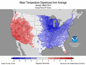
The expression “polar vortex” exploded into public conversation more than a decade ago, when an extreme cold surge engulfed large portions of Canada and the United States. During that period, temperatures fell so drastically that some regions recorded colder conditions than the surface of Mars. Since then, the term become synonymous with severe winter outbreaks, even though the phenomenon itself is neither rare nor new.
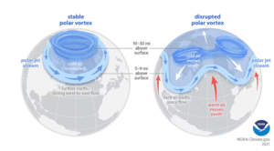
In reality, the polar vortex exists year-round as a ring of strong winds circulating high above the Arctic. Normally, it remains stable and confined to northern latitudes. However, when it becomes unstable, the consequences can be significant. This destabilization allows frigid air to descend much farther south than usual, affecting millions of people across the continent. Because of this, scientists monitor its behavior closely, particularly in early winter when shifts can have widespread impacts.
Signs of a disturbance taking shape
Recent forecasts point to a developing cold pattern that could spread rapidly. Judah Cohen, a climatologist at the Massachusetts Institute of Technology (MIT), noted that the latest European weather model highlights a potentially “impressive cold pattern” now forming. This pattern appears ready to spill southward east of the Rocky Mountains, targeting cities such as Calgary and Winnipeg first. Moreover, this emerging trend has caught the interest of climate scientists across North America.
While cold winters are normal, early and sharp temperature drops frequently indicate significant disruptions occurring in the upper atmosphere. Because these disruptions can unfold quickly, forecasters are urging residents in vulnerable regions to prepare now. Therefore, while uncertainty remains about the full trajectory of the system, several indicators suggest that this event could become one of the earliest polar vortex disturbances recorded in decades.
Understanding how the polar vortex works
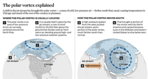
A polar vortex is a vast, spinning mass of cold air situated in the stratosphere, roughly 10 to 50 kilometres above Earth. When stable, the vortex remains isolated near the North Pole. However, when weakened or disrupted, parts of it can break off and move south. This shift happens because the vortex interacts with the jet stream, the fast-moving air current in the troposphere where weather systems form. As the vortex weakens, the jet stream becomes wavier, allowing cold Arctic air to spill southward.
Consequently, regions far from the Arctic experience unseasonably cold conditions that may last for days or even weeks. In addition, the process is influenced by atmospheric waves originating from the surface. These waves can push energy upward, disturbing the vortex and sometimes triggering dramatic warming in the stratosphere. According to researchers, it is this complex interplay that determines the severity and duration of cold outbreaks.
Different types of polar vortex events
Not all disturbances unfold in the same way. Researchers identify several types of polar vortex events, each with distinct characteristics and effects on winter weather.
Sudden stratospheric warming
One scenario is known as sudden stratospheric warming (SSW). This occurs when temperatures in the upper atmosphere rise sharply, often by tens of degrees Celsius within a few days. Although the warming happens high above the surface, the resulting disruption in wind patterns pushes cold air downward. Climatologist Judah Cohen notes that SSW events tend to generate significant public attention. This is because they can produce long-lasting cold spells, even if the initial intensity is moderate. Their wide-reaching influence on atmospheric circulation means they often have lingering effects on weather across the Northern Hemisphere.
Splitting or stretching of the vortex
In some cases, the polar vortex may split into two smaller circulations, sending cold air toward different regions. In others, it may simply stretch southward without breaking apart. Both variations can cause outbreaks of severe cold, though the impacts differ depending on the direction and speed of the displacement. Because these processes develop high in the stratosphere, predicting their evolution is challenging. Despite advances in modelling, meteorologists continue to face uncertainty when determining how far and how fast cold air will spread.
What scientists expect of the early polar vortex arrival
For the moment, experts caution that the exact nature of the early polar vortex arrival remains uncertain. Some indicators support the possibility of a sudden stratospheric warming event, while others suggest a more typical destabilization of the vortex.
According to Michael Sigmond, a research scientist at Environment and Climate Change Canada (ECCC), the latest signals point toward a potential SSW. If confirmed, this would make the event one of the earliest ever documented. Such an early occurrence could have implications for the remainder of the winter, potentially setting the stage for recurring cold outbreaks.
Nevertheless, Sigmond emphasizes that regardless of the mechanism, the outcome will likely be the same: widespread and persistent cold. Therefore, residents across Western and Central Canada should expect temperatures to drop sharply in the coming days.
How far could the cold spread?
While Western and Central Canada are the first expected targets, forecasters are closely watching whether the cold will push farther east. The eventual trajectory depends on how the displaced air interacts with prevailing weather systems.
Judah Cohen explains that the key question is whether the colder air will dive straight south or drift eastward. If it moves south, the United States could face significant impacts as well. However, if it shifts east, provinces such as Ontario, Quebec, and parts of Atlantic Canada may see temperatures plunge soon after.
Because of these uncertainties, meteorologists continue to monitor atmospheric conditions closely. New data in the next few days will refine forecasts and help determine which regions should prepare for the most intense cold.
Canada may be on the brink of an unusually early polar vortex arrival , one that could usher in a prolonged period of severe cold across multiple regions. Although scientists are still determining whether this event qualifies as sudden stratospheric warming or a more typical destabilization, the implications remain substantial. Western and Central provinces appear poised to experience the initial impact, with the possibility of colder air reaching the East shortly afterward. As atmospheric patterns continue to shift, the coming weeks will reveal how widespread the effects become. Ultimately, the event highlights the complexity of winter weather systems and raises broader questions about climate change in a warming world.